Over half a month’s rain could fall within hours as heavy rain and possible lightning threaten travel disruption across southern England and Wales.
A Met Office yellow weather warning is in place for the second day running as wet weather continues due to large patches of rain crossing the channel from France.
Flooding, power cuts and travel disruption are all possible with outbreaks of heavy rain expected to be “persistent” in some areas and “particularly heavy” in others.
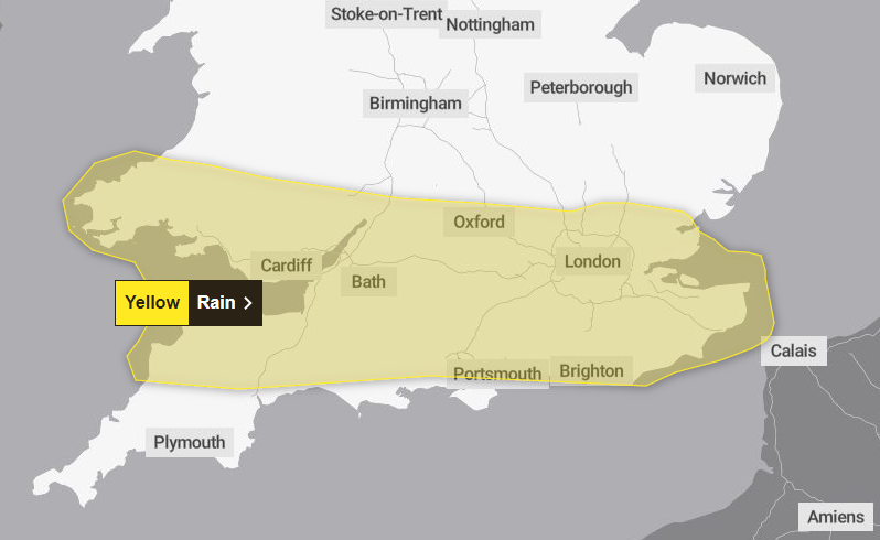
The weather warning area stretches from the south coast up to Oxford, covering almost all southern England and Wales, barring parts of Devon and most of Cornwall. It will be in place until 23:59 Friday night.
Rainfall of up to 40-60mm is possible in the wettest areas, more than half of the September average of 60-90mm in southern England.
The Met warns that there is a small chance of damage to homes and businesses as a result of flooding, with fast flowing and deep floodwater potentially causing a “danger to life”.
Six flood alerts are also in place across southern England.
In pictures: UK outlook for Friday
Southern England and Wales is set for a wet start to the weekend while while the majority of the UK remains dry.
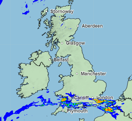
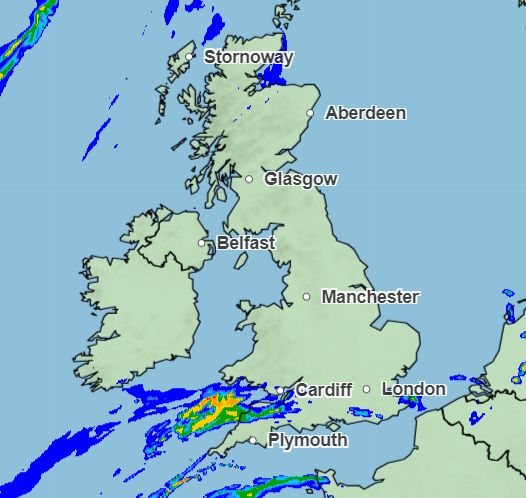
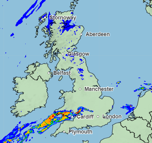
Here’s the picture for today’s rain:
12pm
5pm
10pm
Alex Croft6 September 2024 10:06
Six flood alerts issued by Environment Agency
Six flood alerts have been put in place for areas in the south and south west of England.
River levels are expected to rise as the many parts of southern England experience a second consecutive day of heavy rain.
Alerts have been issued for:
- Lower Avon and tributaries
- River Axe area
- Rivers Clyst and Culm and their tributaries
- Rivers Otter and Sid, and Exmouth area
- Scrase Bridge and West Common Streams
- Tidal Thames riverside from Putney Bridge to Teddington Weir
A flood alert means flooding is possible but not certain – it is the least severe flood notice issued by the Environment Agency, after flood warning and severe flood warning.
Residents in affected areas should have a food plan, medications and insurance documents ready.
Alex Croft6 September 2024 09:02
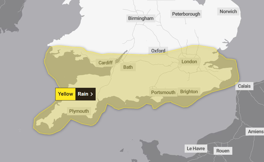
Updated: Areas affected by Friday’s yellow weather warning
The Met Office have updated the area covered by Friday’s yellow weather warning, which will remain in place until 23:59.
Parts of Cornwall and Devon are no longer within the area, with a large area of South Wales now facing possible torrential rain.
Flooding, power cuts and travel disruption are all possible. There may be lightning strikes in northern areas of the warning.
Here is the updated weather warning area:
Alex Croft6 September 2024 08:38
‘North-south divide’
The Met Office told of a North-South divide in the weather, with the South experiencing “pulses of heavy rain” over the next few days and drier, warmer conditions in the North.
The east of the UK should see cool and cloudier weather while the West experiences warmth and sun, with the north west of Scotland potentially seeing temperatures of 27C.
A further warning comes into force throughout Friday, covering a similar area in England and south-east Wales.
Alex Ross6 September 2024 06:00
Rain may lead to travel disruption and flooding
The Met Office said heavy rain may lead to travel disruption and flooding.
Following on from Thursday’s rain, this will increase the possibility of travel disruption from flooding with a slight chance of power cuts and a small chance of some communities being cut off by flooded roads and deep floodwater causing a danger to life.
Commuters and motorists are warned to expect spray and sudden flooding, leading to difficult driving conditions and some road closures.
Alex Ross6 September 2024 03:09
Heavy rain batters southern parts of UK
Heavy rain has battered parts of the UK as forecasters warned of little respite from the deluge on Thursday and Friday.
A yellow warning, issued by the Met Office, is in place until midnight Friday – covering much of the south of Britain – with the risk of flooding across southern England and south Wales, stretching as far north as the West Midlands.
It is likely the Met Office will be issuing further warnings across the weekend, the forecasting body said.
Alex Ross6 September 2024 01:08
‘North/south divide’ – warm Friday expected for northern areas
While the South is battered by heavy rain for two days, temperatures in the west and northwest of Scotland could reach up to 27 C.
Warm weather will stretch to some parts of Northern Ireland, and western and central England.
Met Office Deputy Chief Meteorologist Brent Walker said: “Areas in western Scotland could see maximum temperatures of 26°C on Friday. If the wind were to shift a little, 27°C could even be on the cards for some places in the west as they pick up the foehn effect, which causes warming and drying of air on the lee side of high ground.”
There will be a clear “north/south divide” in the weather, the Met added.
Chief Meteorologist Jason Kelly explained: “[The south is] a different story to the north of the UK though, as high pressure brings warmer and sunnier conditions, with higher-than-average temperatures, particularly across parts of western Scotland. Eastern areas are likely to be cooler and at times, cloudier due to winds blowing off the North Sea.”
Alex Croft5 September 2024 13:28
Weather warning area for Friday shifts south and east
The Met Office have adjusted the weather warning area for Friday.
Oxford and the surrounding area north are no longer included in the yellow weather warning, which is set to bring torrential rain to large parts of the southern UK.
The south western corner of Wales is also now at risk of heavy rain, the revised map shows.
Alex Croft5 September 2024 12:12
How high is the flooding risk?
The Met Office has warned residents in affected areas to check whether their property is at risk of flooding.
It says there is a “small chance of fast flowing or deep floodwater causing danger to life” on both Thursday and Friday, leading to potential travel disruption, damage to homes and buildings, and the small possibility that “some communities will become cut off by flooded roads”.
Those who may be at risk of flooding should consider preparing an emergency flood kit and a food plan, the Met Office said.
“Where flooding occurs, there is a slight chance of delays or cancellations to train and bus services. Spray and flooding could lead to difficult driving conditions and some road closures.”
But there are currently no alerts in place from the Environment Agency, which is responsible for putting out flood alerts for areas which could be at risk.
Alex Croft5 September 2024 10:21
Month’s worth of rain possible in two days
The worst affected areas over the next two days could see up to a month of rainfall in the space of just hours.
Heavy downpours over longer periods could see as much as 80mm to 100mm of rain for locations which are affected repeatedly – which the Met say is possible during the second half of Thursday.
Moving into Friday, the worst affected areas will likely see 40-60mm throughout the day, with a lower likelihood of some areas seeing as much as 75-100mm. Rain may also be accompanied by thunderstorms.
With the average September rainfall for southern England and South Wales around 60-90mm, some areas could smash their average in the space of just hours.

Alex Croft5 September 2024 10:15